Phil Konstantin's 2003 Vacation: Page 2003 A = Nez Perce Area - Grangeville to Kamiah, Idaho


Click on any picture below to see a larger version of it.


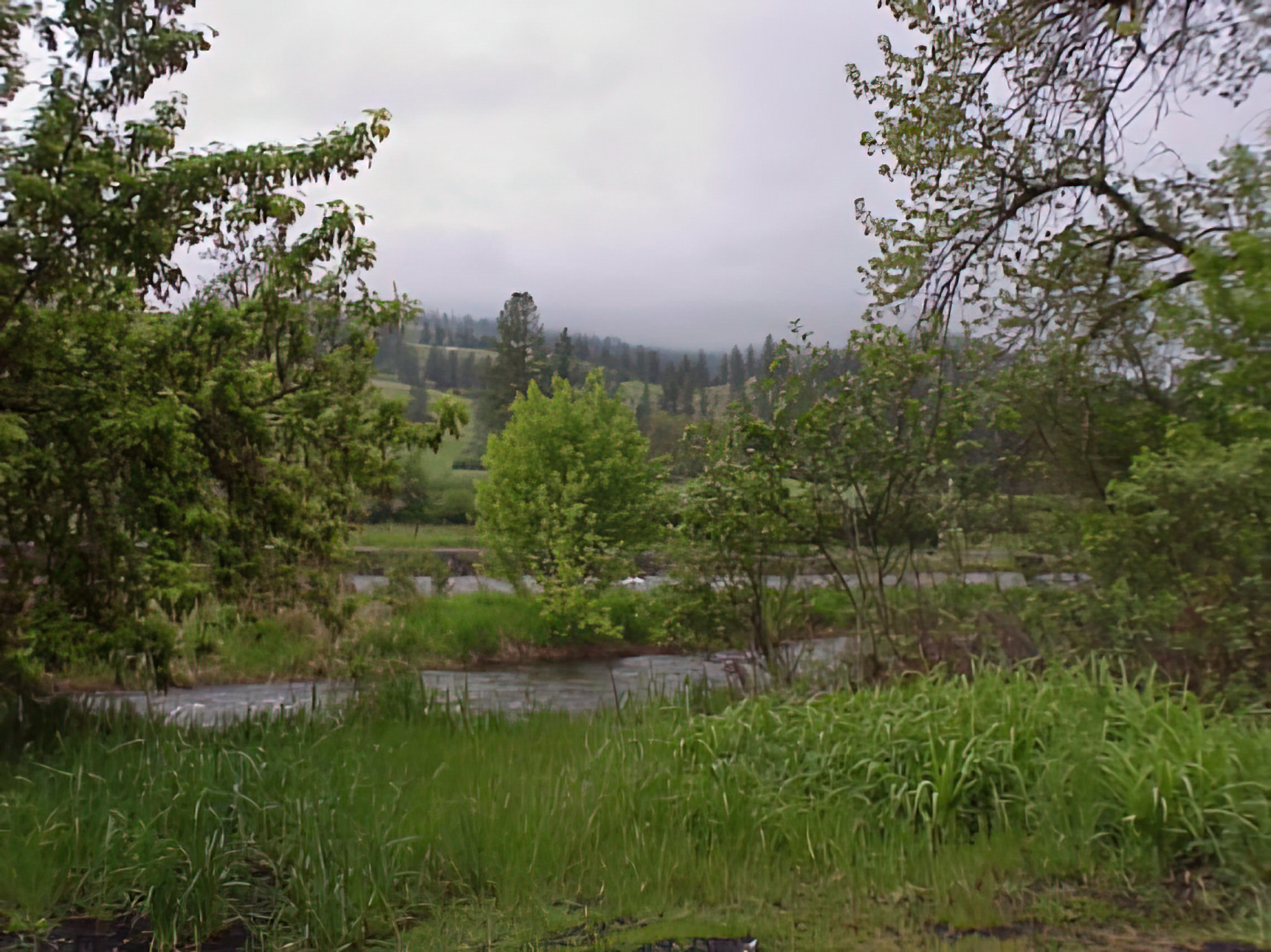
This picture was taken the morning of May 18, 2003, not far from Grangeville, Idaho.

This is the entry from my book: "Wahlitits and two other members of White Bird’s Band of Nez Perce killed a man named Richard Devine. The next day they killed three more men."
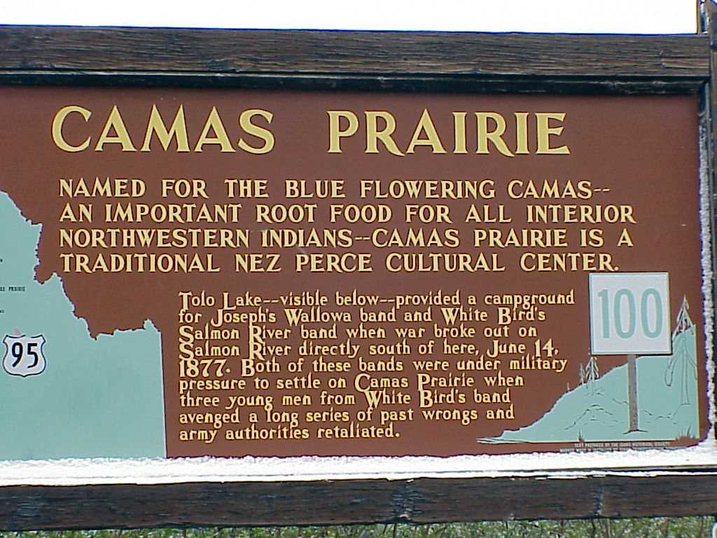
Tolo Lake...
Many Nez Perce gathered here in June, 1877. The lake was named after a Nez Perce woman named Tuiekats Chikchamit. She was called Tolo by the settlers, who had trouble pronouncing her name. The Nez Perce name for Tolo Lake is Tepahlewam (Split Rocks).

Click here to read about the hundreds of mammoth bones discovered around Tolo Lake in 1994.

There is quite a grade between Grangeville and White Bird. At this elevation, the clouds were always close.

This sign marks the area of the White Bird Battlegrounds near Highway 95, south of Grangeville.

This is the entry from my book for June 15, 1877: "The Nez Perce deadline to be on the reservation arrived. Whites were at Grangeville."

Click here to see a detailed website about the battle from the National Park Service.
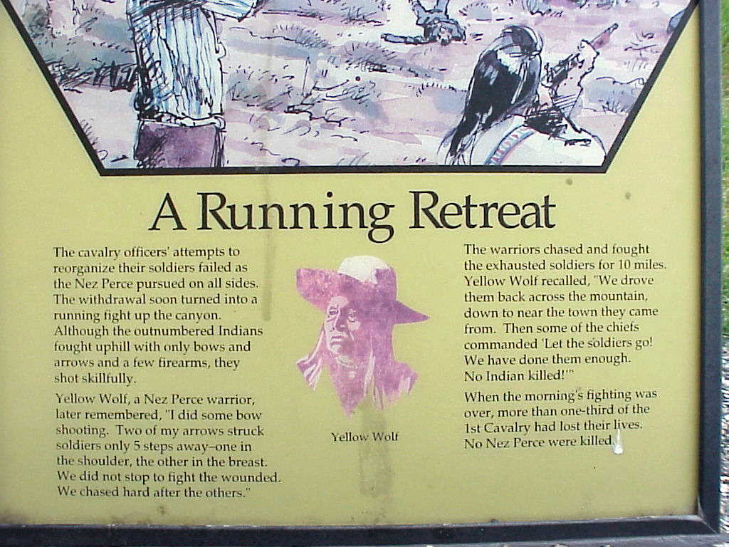


The signs are very informational.


This map/picture shows the movements of the different groups.

The entry from my book: "Another battle took place between the army and the Nez Perce. The army was led by Captain David Perry. There were approximately 140 warriors in the group. This was called the Battle of White Bird Canyon. The army unit had difficulty coordinating its actions because one trumpeter had been killed and the other lost his trumpet. According to army records, during the retreat First Lieutenant William Parnell, First Cavalry, would return and rescue a soldier whose horse had been shot out from under him. For these actions, Parnell would be awarded the Congressional Medal of Honor. Lieutenant E. R. Theller and thirty-three soldiers were killed. No Nez Perce casualties were reported. The battlefield was at White Bird, south of Grangeville, Idaho."

...more of the map...


This is a panoramic view of four merged pictures showing the area on the map/picture above. From left to right is northeast to southeast. "H" hill is the notch on the right.


"Before you, to the westward lies the historic Whitebird Battleground of the Nez Perce Indian War in which thirty-five men gave up their lives in service for their country. June 17, 1877 --- Beneath this shaft lies one of those brave men laid to rest where he fell."

The top horizontal cut through the hills is Highway 95. The cut just below that is a road through the Whitebird battlefield. This is looking south.

The wispy tendrils of condensation gently draped themselves around the shoulders of the verdent forest's conifer sentinels.

The Clearwater River battle took place near Highway 13 on the east side of the Nez Perce reservation, near Stites, Idaho.

The Clearwater River and the area where the battle took place.

The entry from my book: "General Oliver Howard, called 'Cut Arm' or 'One Armed Soldier Chief' by the Indians, was leading 550 First Cavalry, Twenty-First Infantry, and Fourth Artillery soldiers when they spotted the Nez Perce along the Clearwater River and Cottonwood Creek. The fighting lasted until the next day, when the army got reinforcements. The Nez Perce then retreat to the north. During the fighting the army reported that it lost fifteen dead and twenty-five wounded soldiers and killed twenty-three warriors. Accounts from Nez Perce survivors put their losses at only four. First Lieutenant Charles F. Humphrey, Fourth Artillery, “voluntarily and successfully conducted in the face of withering fire, a party which recovered possession of an abandoned howitzer and two Gatling guns lying between the lines a few yards from the Indians.” For his actions, Humphrey would be awarded the Congressional Medal of Honor. The fighting lasted through the next day."
According to most sources, the four Nez perce who died here were: Heinmot Ilppilp (Red Thunder) and Lelooskin (Whittling), Wayakat (Going Across) and Yoomtis Kunin (Grizzly Bear Blanket)

Click here for a basic NPS site about the battle
Click here for a detailed NPS site about the battle
A sign in English and phonetic Nez Perce at the Nez Perce National Historic Park (East Kamiah Site).


Near the small town of Kamiah is a special site for the Nez. Tradition says (and I paraphrase greatly) that Coyote noticed that a great beast was eating up all of the animals of the world. He intentionally got himself caught by the beat, who then ate him. Inside the beast, Coyote met a bear who growled at him. Coyote kicked him in the nose. That is why bears have flat noses. Coyote then met a snake who hissed at him. Coyote stepped on the snake's head. This is why snakes have flat heads. Using his hidden tools, Coyote started a fire inside the beast. He also used his knife to start cutting a way out of the beast. Eventually, the beast died, and the animals escaped. Coyote continued to cut up the beast. He cast aside pieces of the beast into the mountains around him. Wherever a piece landed, a tribe was created, such as the Yakama. After he had finished cutting up the beast, and spread its remains, an animal asked Coyote if he was going to create some people to live in the valley were they fight had occurred. All that was left of the beast was its heart. Coyote reached into the heart, and grabbed a piece. He shook it around and wherever the blood landed, the Nee-me-poo sprang up. This is how the Nee-me-poo came to be. The beast's heart can still be seen.


...details of the story...

This is the "Heart of the Monster" in Kamiah, Idaho on the Nez Perce's reservation.


...another look at the "Heart of the Monster"...

I thought this area was very beautiful. The elevation here is apporoximately 1,200 feet.


Click here to return to my main page
Click here to go to the next page (Kamiah to Lolo Pass) 
 Click here to go to previous page (Spokane to Grangeville)
or
Click on the description below to go to that page directly.


Page 2003: Spokane, Washington to Grangeville, Idaho Page 2003a: Grangeville, Idaho to Kamiah, Idaho Page 2003b: Kamiah to Lolo Pass Page 2003c: Lolo, Montana to Salmon, IdahoPage
Page 2003d: Salmon, Idaho to Gilmore Summit, Idaho Page 2003e: Kilgore, Idaho to Yellowstone National Park Page 2003f: More Yellowstone Page 2003g: Grand Tetons to Lander, Wyoming
Page 2003h: Wind River Canyon to Legend Rock, Wyoming Page 2003i: Medicine Lodge State Archaeological Site to Red Gulch Dinosaur Tracksite, Wyoming Page 2003j: Shell Creek Falls to Wagon Box Battlefield, Wyoming Page 2003k: Rosebud Battlefield to Little Bighorn Battlefield, Montana
Page 2003l: Little Bighorn Battlefield to Crow Agency, Montana Page 2003m: Fetterman Battlfield to Fort Phil Kearny, Wyoming Page 2003n :Crazy Woman Creek to Fort Fetterman, Wyoming Page 2003o: Oregon Trail to Fort Laramie, Wyoming
Page 2003p: Grattan Battlefield, Wyoming to Fort Robinson, Nebraska Page 2003q: Hudson-Meng Bison Bonebed, Nebraska to Crazy Horse Monument, South Dakota Page 2003r :Devil's Tower, Wyoming Page 2003s: Rapid City to Badlands National Park, South Dakota
Page 2003t: Eagle Butte Powwow to the Blessing Ceremony Page 2003u: Sakakawea Monument to Fort Buford Page 2003v: Fort Union to Old Fort Peck Page 2003w: Cree Crossing to Fort Assiniboine
Page 2003x: Glacier Park#1 Page 2003y: Glacier #2 to Missoula, Montana Page 2003z:blank (so far) Home Page


Google
 
Web americanindian.net


Click on the drop down menu:

or
Click on the image below to go to......

My website's home page My Website's Home Page My main links page with connections to thousands of other websites Links: (8,700 and counting) my page with tribal name meanings & alternate tribal names Tribal Names
Indian tribal moon names & other calendar information Indian Moons My personal photos Personal Photos My biography My Biography
What happened to a sleepy driver Sleepy Driver My website about NASA & the Space Program The Space Program photos & info of my trip to some ancient ruins in Mexico & Guatemala Ancient Ruins in Central America
photos & info on my trip to some ancient Maya ruins in 2000 Maya Ruins in Mexico My late wife Robyn's page about whales & whale watching Whales Awards this site has received & WebRings to which this site belongs Awards & Webrings
photos & descriptions of the 2001 Cherokee National Holiday in Tahlequah, Oklahoma Cherokee Holiday 2001 a page with basic info for the Cherokee Nation (Oklahoma) Cherokee Enrollment an archive of my past monthly newsletters My Newsletters
places where you can shop to support this site My Store a page about the California Highway Patrol California Highway Patrol locations of 'Indian Era' forts Indian Era Forts
copies of articles I have written Articles I Wrote photos of northwestern USA historical sites & reservations Northwestern USA Indian Country photos of the opening of the National Museum Of The American Indian in Washington, D.C. ( 2004) American Indian Museum in D.C. 2004
reviews of Movies, Books and other things... Movie & Book Reviews photos an info about the guests and happenings at KUSI TV in San Diego KUSI TV, my other job photos of Mesa Verde and Utah in 2006 Mesa Verde and Utah in 2006
My mortgage loan compnay My Mortgage Loan Company photos of the 2006 SDSU powwow 2006 SDSU Powwow photos of mostly California beaches Beach Photos


(© copyright 1996-2008)